sexta-feira, 2 de novembro de 2018

031 - Monumento do Lousal


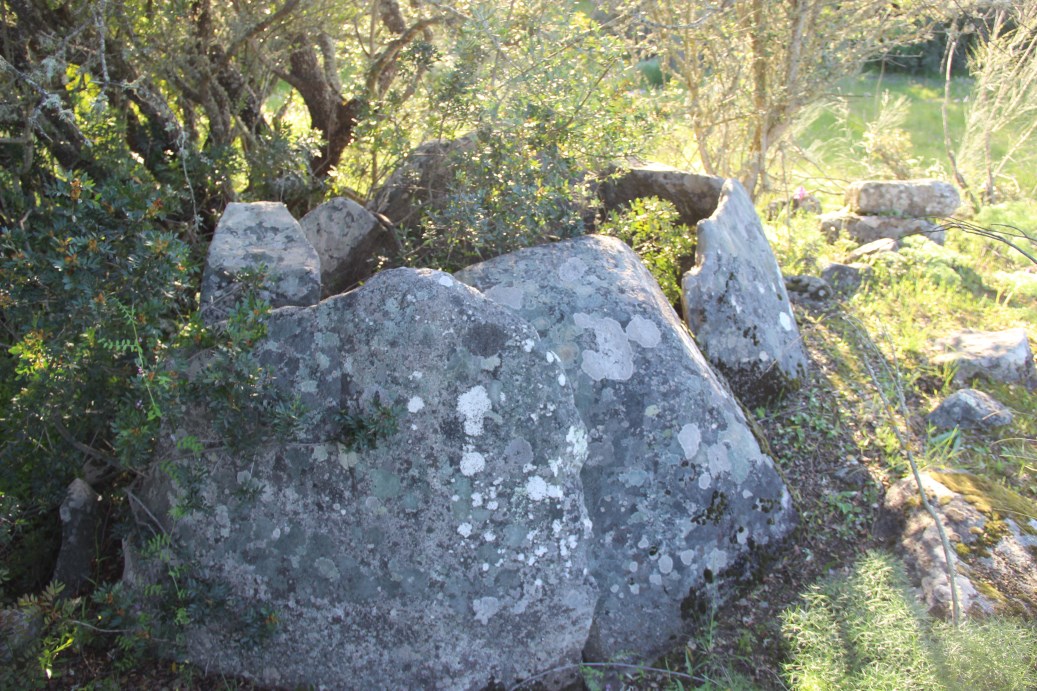
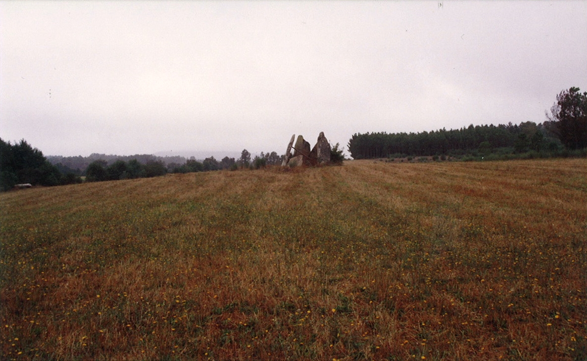
Chronology: Chalcolithic

Located near the Lousal  mines, Azinheira dos Barros village, municipality of Grândola, district of Setúbal.
Access:  At the entrance of the mines agglomeration, take a left earth road (a plaque indicates the road to the monument). Follow the road for 1.700m where plaques indicate the way. The monument will be at your right.
Accessible to normal cars (might have problems in winter).
Coordinates: 38º0236,12 8º2619,74

Ver no GOOGLE MAPS

The monument has a structure designed for visitors. A cleaning the vegetation and repairing the wood walkway is needed,though.


sexta-feira, 12 de outubro de 2018

030 - Anta Grande da Comenda da Igreja


Chronology: Neolithic and Chalcolithic

National Monument since 1936.

Located in Herdade da Comenda da Igreja, municipality of Montemor-o-Novo, district of Évora.
Access:  From the São Geraldo village, course de N2 road south for 500m. After a turn right there is a gate to a earth road at right. Course the road for 600m until the monument.
Accessible to normal cars (might have problems in winter).
Coordinates: 38.45288º / 8.12115º

Ver no GOOGLE MAPS

Images of a National Monument:


segunda-feira, 8 de outubro de 2018

029 - Dolmen de Alcobertas


Chronology: Neolithic

Located inside the village of Alcobertas, municipality of Rio Maior, district of Santarém.
Access:  It is integrated as a lateral chapel in the Maria Madalena Church inside the village.
Accessible to normal cars.
Coordinates: 39.25068º / 8.54127º

Ver no GOOGLE MAPS


The access by the inside of the church, still with part of the megalithic passage preserved.


A huge guillotine stone at the entrance of the chamber 


The chamber turned into a chapel.


Some cup marks in the monoliths. 

sexta-feira, 28 de setembro de 2018

028 - Anta da Vidigueira


Chronology: Neolithic, Chalcolithic

Classified as National Monument since 1910.

Located near Freixo village, municipality of Redondo, district of Évora.
Access: At the north entrance of Freixo village, course the road to SW for 1,100 m. Then turn left, and course more 200m. The monument will be at your left, just next to the road.
Accessible to normal cars.
Coordinates: 38.403500º / 7.393439º

VER NO GOOGLE MAPS

Bibliography: Mataloto, R.; Boaventura, R. (2010), Anta da Vidigueira (Freixo, Redondo): intervenção de caracterização, Revista de Arqueologia Portuguesa, 13: 5-24.


sexta-feira, 14 de setembro de 2018

Actualizações e outras notas (1)

Lentamente, o megalitismo, talvez a primeira arquitectura construída nestas terras com um desígnio de longa duração, vai cedendo ao tempo. Mesmo num tempo que a reconheceu, em parte a compreendeu, e lhe conferiu estatuto de património. Na recente volta que ando a dar aos meus registos fotográficos do megalitismo português tomei consciência de algo que me passou despercebido, resultado de intervalos grandes entre visitas. Comparando fotografias de Cebolinhos 1 de 2008, com as tiradas este ano de 2018, verifica-se que um dos grandes esteios tombou, ao fim de mais de 5000 anos. A gravidade é tramada. Não só a que é gerada pelo movimento da Terra, mas sobretudo a que é gerada pela incuria de quem deveria, por função ou condição, proteger este património. Ou seja, mais ou menos todos nós. Ficamos, pois à espera de ver quanto mais tempo resiste um dos maiores monumentos megalíticos do país e da península, e que fica lá mais para as bandas de Évora. Começo a duvidar que me sobreviva.


Cebolinhos 1 em 2008


Cebolinhos 1 em 2018


027 - Anta de São Gens


Chronology: Neolithic

Located in Alpalhão, municipality of Nisa, district of Portalegre.
Access: Take the road M1176 at Alpalhão heading NW and course it for 6km. The monument will be at your right, at 50m of the road.  Accessible by normal car.

Coordinates: 39.265303º / 7.403434º

VER NO GOOGLE MAPS

Bibliography:


quinta-feira, 13 de setembro de 2018

026 - Anta 1 da Comenda


Chronology: Neolithic

As Comenda 2, abandoned in the bushes.

Located in Contenda farm, São Pedro do Corval village, municipality of Reguengos de Monsaraz, district of Évora.
Access: In the road N256 coming from Reguengos de Monsaraz, take a track at left 1,600 before reaching the cross to Monsaraz. Course the track always north for 1.900m and, in the meddle of a vineyard, turn left for 100m. You will be at a gate. The monument is 170mm W of the gate, in the meddle of trees. The rest of the way is done by foot. It is about 100m from Comenda 2.
Accessible only to jeep type cars. In winter even for those might be complicated.
Coordinates: 38.25551º / 7.26157º

VER NO GOOGLE MAPS

Bibliography: Leisner, G.; Leisner, V. (1951) - Antas do Concelho de Reguengos de Monsaraz, Lisboa.


sábado, 8 de setembro de 2018

025 - Anta 3 dos Cebolinhos


Chronology: Neolithic.

Located in Cebolinhos farm, Campinho village, municipality of Reguengos de Monsaraz, district of Évora.
Access: from the last cross to Campinho, take the left track for 2450m to Monte dos Cebolinhos. At the car parking near the houses, cross the gate at left and course the track for 120m, then take the right track. Course it for 420. The monument will be at your left, about 75m from the track, under a tree.
Accessible to normal cars until the gate. The rest is better done by foot if you do not have a jeep type of car.
Coordinates: 38.232579º / 7.291413º

VER NO GOOGLE MAPS

Bibliography: Leisner, G.; Leisner, V. (1951) - Antas do Concelho de Reguengos de Monsaraz, Lisboa.


domingo, 2 de setembro de 2018

024 - Anta de Pendilhe


Also known as Orca or Casa da Moura de Pendilhe

Chronology: Neolithic and Chalcolithic (?)

Located in Pendilhe village, municipality of Vila Nova de Paiva, district of Viseu.
Access: In the center of Pendilhe village, take the Rua Ribeirinho heading SW. Course it for 1.300. The monument will be at left, just next to the road.
Accessible by normal car.
Coordinates: 40.535327º / 7.492534º

VER NO GOOGLE MAPS

Bibliography:


sexta-feira, 31 de agosto de 2018

023 - Anta 2 e Tholos da Comenda


Chronology: Neolithic and Chalcolithic

It is a Neolithic dolmen with a Chalcolithic tholos attached.

Located in Contenda farm, São Pedro do Corval village, municipality of Reguengos de Monsaraz, district of Évora.
Access: In the road N256 coming from Reguengos de Monsaraz, take a track at left 1,600 before reaching the cross to Monsaraz. Course the track always north for 1.900m and, in the meddle of a vineyard, turn left for 100m. You will be at a gate. The monument is 200m SW, in the meddle of trees. The rest of the way is done by foot.
Accessible only to jeep type cars. In winter even for those might be complicated.
Coordinates: 38.255266º / 7.261660º

VER NO GOOGLE MAPS

Bibliography: Leisner, G.; Leisner, V. (1951) - Antas do Concelho de Reguengos de Monsaraz, Lisboa.


This is how the dolmen and the tholos looked  in the fourthies of the XX century, when excavated by the Leisner. (Photo taken from Leisner, Leisner, 1951).


This is how the dolmen and the passage of the tholos look like today.


quinta-feira, 30 de agosto de 2018

022 - Dolmen da Sobreda


Chronology: Neolithic, Chalcolithic. With Bell Beakers.

Located in Sobreda village, municipality of Oliveira do Hospital, district of Coimbra.
Access: From Sobreda roundabout, take the second track left. Course it for 800m, then take a track at left and course more 80m. The monument will be in your left, in a small hill. Access to normal cars, but parts of the track may be dificult. There are sinning plaques, but not all the way.
Coordinates: 40.270855º / 7.481945º

VER NO GOOGLE MAPS

Bibliography: Senna-Martinez, J.C. (1982) - Materiais campaniformes do concelho de Oliveira do Hospital (Distrito de Coimbra), Clio, IV, p.19-34.


domingo, 26 de agosto de 2018

021 - Dolmen de São Pedro de Dias


Chronology: Neolithic.

Only the mound is present and partially preserved. It was here that I initiated my archaeological activities as student in the year of 1982. The area was burned in 1982 and again in 2017.

Located in Poiares (Santo André), municipality of Vila Nova de Poiares, district of Coimbra.
Access: Just next the road N17, behind the inn in front of the chapel of S. Pedro de Dias, between the villages of Vale Tronco and S. Miguel de Poiares. Accessible to normal cars until the inn.
Coordinates: 40.140788º / 7.552623º


VER NO GOOGLE MAPS

Bibliography: Senna-Martinez, J.C. (1989) - Pré-História Recente da bacia do médio e alto Mondego. Algumas contribuições para um modelo sociocultural. Dissertção de doutoramento, FLUL, Lisboa.


sexta-feira, 24 de agosto de 2018

020 - Dolmen da Malhada do Cambarinho


Chronology: Neolithic.

Located in Joana Martins, Vouzela municipality, district of Viseu.
Access: Integrated in the route of Penoita natural parck (burned in 2017). There are plaques indicating the way from Vouzela, direction Vilharigues (cross at left). The last plaques indicates a turning to south to a small road. The monument is at left of that road, at 200m. From the road only accessible by foot.
Coordinates: 40.404772º / 8.071377º

VER NO GOOGLE MAPS

Bibliography:


quarta-feira, 22 de agosto de 2018

019 - Orca do Outeiro do Rato


Chronology: Neolithic, Chalcolithic. With Bell Beaker pottery.

Located in Fiais da Telha village, municipality of Carregal do Sal, district of Viseu.
Access: Coming from Lapa do Lobo village, turn left before entering in Fiais da Telha, in a road leading to the football field.  After 90m take the left track and course it for 1000m. The monument will be in your right, track from the football field. Accessible to normal cars, but a bit hard. There some plaques indicating the way, but not all he way. Using the coordinates is useful.
Coordinates: 40.274727º / 7.552623º

VER NO GOOGLE MAPS

Bibliography: Senna-Martinez, J.C. (1989) - Pré-História Recente da bacia do médio e alto Mondego. Algumas contribuições para um modelo sociocultural. Dissertção de doutoramento, FLUL, Lisboa.


018 - Cebolinhos 1


Chronology: Neolithic.

Located in Cebolinhos farm, Campinho village, municipality of Reguengos de Monsaraz, district of Évora.
Access: from the last cross to Campinho, take the left track for 2450m to Monte dos Cebolinhos. Continue for another 350m and take a track on the left. For that you will have to open a gate. Course the track heading South for 260m. The monument will be on your left.
Accessible to normal cars until the gate. The rest is better done by foot if you do not have a jeep type of car.
Coordinates: 38.231457º / 7.293227º

VER NO GOOGLE MAPS

Bibliography: Leisner, G.; Leisner, V. (1951) - Antas do Concelho de Reguengos de Monsaraz, Lisboa.


017 - Anta da Melriça


Also known as Anta da Fonte das Mulheres.

Chronology: Neolithic.

Located in Melriça, Santiago Maior, municipality of  Castelo de Vide, district of Portalegre.
Access: 350m NE of the cross between N246 and M1007. From the cross only accessible by foot. cars.
Coordinates: 39.255920º / 7.300666º

VER NO GOOGLE MAPS

Bibliography:

terça-feira, 21 de agosto de 2018

016 - Dolmen da Pedra Branca


Chronology: Neolithic.

Located in Vale Figueira, Melides village, municipality of Grândola, district of Setúbal.
Access: From the football field of Vale Figueira, haed south in a track for about 1500m. Accessible to normal cars.
Coordinates: 40.450993º / 7.275035º

VER NO GOOGLE MAPS

Bibliography:


015 - Carapito 1


Today is a pile of stones covered with bushes, although is a classified monument.

Chronology: Neolithic.

Located in Carapito village, municipality of Aguiar da Beira, district of Guarda.
Access: From Carapito take the road to Queiriz for 400m. The monument is at the left side of the road, at 50m. Accessible to normal cars.
Coordinates: 40.450993º / 7.275035º

VER NO GOOGLE MAPS

Bibliography: Senna-Martinez, J.C. (1989) - Pré-História Recente da bacia do médio e alto Mondego. Algumas contribuições para um modelo sociocultural. Dissertção de doutoramento, FLUL, Lisboa.


It has decorated monoliths with carved suns.


segunda-feira, 20 de agosto de 2018

014 - Anta da Cavada


Also known as Dolmen dos Fiais da Beira.

Chronology: Neolithic.
Located in Fiais da Beira village, municipality of Oliveira do Hospital, district of Coimbra.
Access: inside the village of Fiais, while heading East, take a left road indicated by a plaque.  Follow the track for about 500m The monument will be at your left.  Accessible to normal cars with some difficulties. Part of the track is better done by foot if you do not have a jeep type of car. There are plaques indicating the way, but just at the beginning of the track.
Coordinates: 40.245867º / 7.551450º

VER NO GOOGLE MAPS

Bibliography: