Mostrando postagens com marcador Concelho Reguengos de Monsaraz. Mostrar todas as postagens

sexta-feira, 14 de setembro de 2018

Actualizações e outras notas (1)

Lentamente, o megalitismo, talvez a primeira arquitectura construída nestas terras com um desígnio de longa duração, vai cedendo ao tempo. Mesmo num tempo que a reconheceu, em parte a compreendeu, e lhe conferiu estatuto de património. Na 
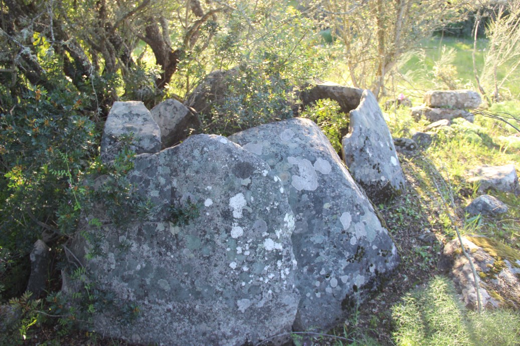
recente volta que ando a dar aos meus registos fotográficos do megalitismo português tomei consciência de algo que me passou despercebido, resultado de intervalos grandes entre visitas. Comparando fotografias de Cebolinhos 1 de 2008, com as tiradas este ano de 2018, verifica-se que um dos grandes esteios tombou, ao fim de mais de 5000 anos. A gravidade é tramada. Não só a que é gerada pelo movimento da Terra, mas sobretudo a que é gerada pela incuria de quem deveria, por função ou condição, proteger este património. Ou seja, mais ou menos todos nós. Ficamos, pois à espera de ver quanto mais tempo resiste um dos maiores monumentos megalíticos do país e da península, e que fica lá mais para as bandas de Évora. Começo a duvidar que me sobreviva.


Cebolinhos 1 em 2008


Cebolinhos 1 em 2018


quinta-feira, 13 de setembro de 2018

026 - Anta 1 da Comenda


Chronology: Neolithic

As Comenda 2, abandoned in the bushes.

Located in Contenda farm, São Pedro do Corval village, municipality of Reguengos de Monsaraz, district of Évora.
Access: In the road N256 coming from Reguengos de Monsaraz, take a track at left 1,600 before reaching the cross to Monsaraz. Course the track always north for 1.900m and, in the meddle of a vineyard, turn left for 100m. You will be at a gate. The monument is 170mm W of the gate, in the meddle of trees. The rest of the way is done by foot. It is about 100m from Comenda 2.
Accessible only to jeep type cars. In winter even for those might be complicated.
Coordinates: 38.25551º / 7.26157º

VER NO GOOGLE MAPS

Bibliography: Leisner, G.; Leisner, V. (1951) - Antas do Concelho de Reguengos de Monsaraz, Lisboa.


sábado, 8 de setembro de 2018

025 - Anta 3 dos Cebolinhos


Chronology: Neolithic.

Located in Cebolinhos farm, Campinho village, municipality of Reguengos de Monsaraz, district of Évora.
Access: from the last cross to Campinho, take the left track for 2450m to Monte dos Cebolinhos. At the car parking near the houses, cross the gate at left and course the track for 120m, then take the right track. Course it for 420. The monument will be at your left, about 75m from the track, under a tree.
Accessible to normal cars until the gate. The rest is better done by foot if you do not have a jeep type of car.
Coordinates: 38.232579º / 7.291413º

VER NO GOOGLE MAPS

Bibliography: Leisner, G.; Leisner, V. (1951) - Antas do Concelho de Reguengos de Monsaraz, Lisboa.


sexta-feira, 31 de agosto de 2018

023 - Anta 2 e Tholos da Comenda


Chronology: Neolithic and Chalcolithic

It is a Neolithic dolmen with a Chalcolithic tholos attached.

Located in Contenda farm, São Pedro do Corval village, municipality of Reguengos de Monsaraz, district of Évora.
Access: In the road N256 coming from Reguengos de Monsaraz, take a track at left 1,600 before reaching the cross to Monsaraz. Course the track always north for 1.900m and, in the meddle of a vineyard, turn left for 100m. You will be at a gate. The monument is 200m SW, in the meddle of trees. The rest of the way is done by foot.
Accessible only to jeep type cars. In winter even for those might be complicated.
Coordinates: 38.255266º / 7.261660º

VER NO GOOGLE MAPS

Bibliography: Leisner, G.; Leisner, V. (1951) - Antas do Concelho de Reguengos de Monsaraz, Lisboa.


This is how the dolmen and the tholos looked  in the fourthies of the XX century, when excavated by the Leisner. (Photo taken from Leisner, Leisner, 1951).


This is how the dolmen and the passage of the tholos look like today.


quarta-feira, 22 de agosto de 2018

018 - Cebolinhos 1


Chronology: Neolithic.

Located in Cebolinhos farm, Campinho village, municipality of Reguengos de Monsaraz, district of Évora.
Access: from the last cross to Campinho, take the left track for 2450m to Monte dos Cebolinhos. Continue for another 350m and take a track on the left. For that you will have to open a gate. Course the track heading South for 260m. The monument will be on your left.
Accessible to normal cars until the gate. The rest is better done by foot if you do not have a jeep type of car.
Coordinates: 38.231457º / 7.293227º

VER NO GOOGLE MAPS

Bibliography: Leisner, G.; Leisner, V. (1951) - Antas do Concelho de Reguengos de Monsaraz, Lisboa.